 |
|
|

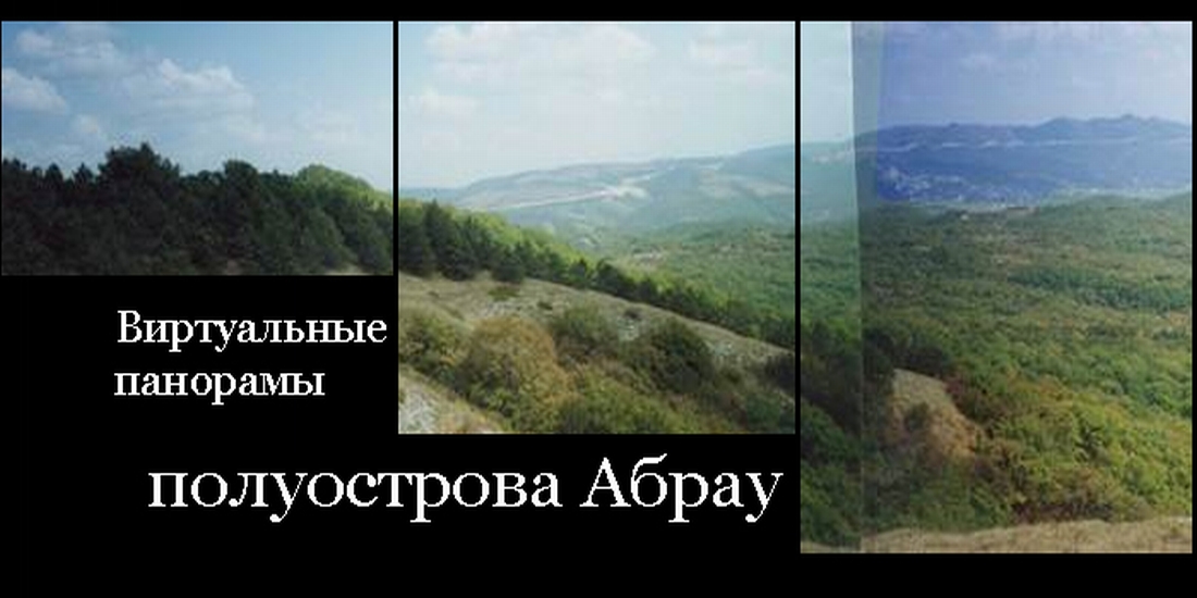
Проект : «Воссоздание виртуальной многоуровней модели антропогенного ландшафта полуострова Абрау в античную эпоху по данным археологии» проводится при финансовой поддержке гранта РГНФ, № 13-01-12017 (2013 - 2015).
Авторы : А.А. Малышев, И.С. Торопов, Д.И. Жеребятьев, С.В. Ольховский, В.С. Батченко
Цель проекта: Целью проекта является построение многоуровневой виртуальной реконструкции антропогенного ландшафта одного из регионов северного Причерноморья, который являлся составной частью Боспорского государства. Территория между современными Анапой и Новороссийском, в античное время Горгиппия и Бата-гавань, в специальной литературе получила название полуострова Абрау.
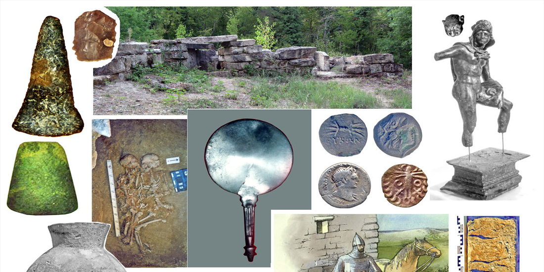
Данные письменных источников об истории этого региона крайне ограничены. Тем не менее, благодаря многолетним комплексным исследованиям получен большой материал, позволяющий воссоздать не только связную картину этнополитической истории этого региона, но и, благодаря специфике археологического источника, эволюцию антропогенного ландшафта этого региона на довольно значительном хронологическом промежутке. Наиболее значительны и многообразны эти данные по античной эпохе, периоду нахождения этого региона в составе Боспорского государства.
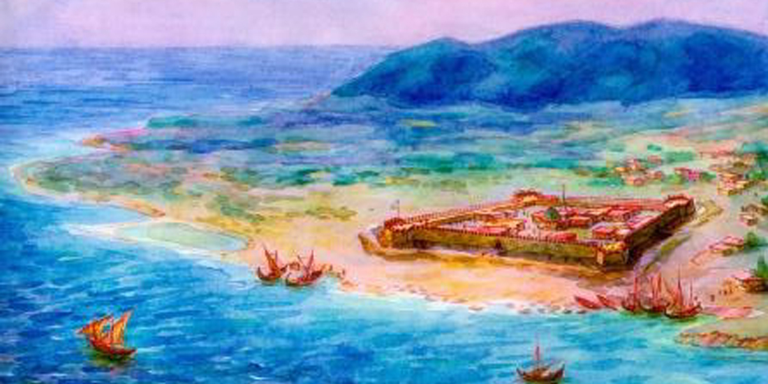
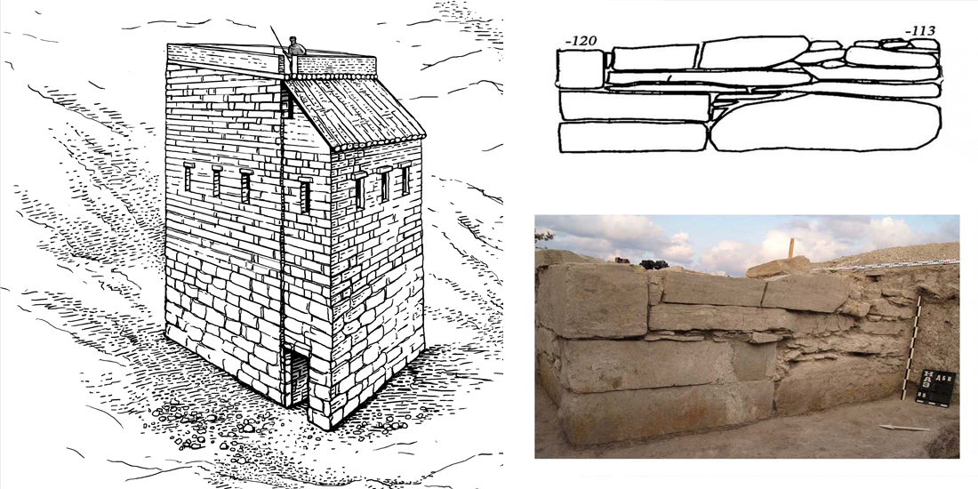
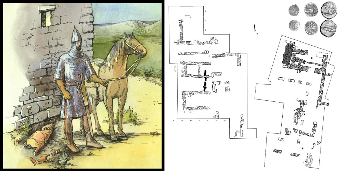
Основным объектом реконструкции является история Раевского городища, расположенного в окрестностях г. Новороссийска. Географическое положение, выявленные здесь сооружения и комплексы свидетельствуют о его значении, как административного центра, осуществлявшего контроль над материковой частью полуострова. Городище, занимающее площадь около 15 га, исследуется с конца XIX в. Выявлено два пояса оборонительных сооружений с цитаделью раннеримской эпохи, обширный участок эллинистической застройки с перистильным двориком, остатки бастионов крепости турецкого времени.
Накопленный объем данных позволяет произвести детальную пространственную реконструкцию эволюции фортификационной системы этого центра и других монументальных сооружений. Эта реконструкция будет производиться с помощью современных средств трехмерного моделирования, и ее главным результатом будет создание виртуальной модели в среде Unity, которая позволяет пользователю свободно перемещаться в пространстве трехмерной модели и будет давать исчерпывающее представление об архитектурном облике Раевского городища на всех этапах его существования.
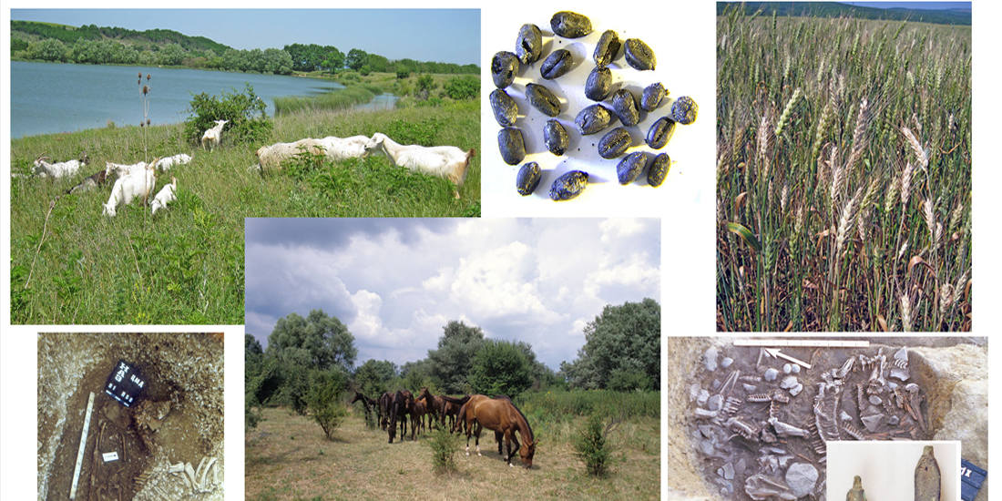
В раннеримское время административный центр на Раевском городище контролировал обширную сеть блок-постов - укрепленных усадеб, в которых дислоцировались небольшие подразделения регулярной армии Боспорского государства. Задачей этого проекта является воссоздание системы расселения на полуострове Абрау в раннеримское время с учетом данных о природно-климатической обстановке в эту эпоху.
Модели планируется разместить на созданном для этого сайте "ABRAU ANTIQUA" в сети Интернет, сделав их доступными для всего научного сообщества и широкого круга интересующихся древней историей. Полученные трехмерные модели будут использованы для археологических пространственных исследований и в качестве иллюстративного материала.
Проект : Виртуальная реконструкция московского монастыря «Всех скорбящих радости»: анализ эволюции пространственной инфраструктуры на основе методов 3D моделирования (Virtual Reconstruction of Moscow Monastery «All Sorrow Joy»: Analysis of Spatial Infrastructure Evolution on Bases of 3D Modelling methods) проводится при финансовой поддержке гранта РФФИ, № 11-06-00453a.
Авторы : Л.И. Бородкин, И.М. Гарскова, Д.И. Жеребятьев, В.А. Простов
Цель проекта: Целью проекта является построение виртуальной реконструкции одного из наиболее крупных московских монастырей – монастыря «Всех скорбящих радости». Рассматриваемый монастырский комплекс располагался на севере Москвы и к концу XIX в. включал более 25 строений, включая уникальные памятники церковного храмового зодчества (главный храм Всемилостивого Спаса и храм Архангела Рафаила). Практически все эти строения в советское время были снесены, и территория монастыря была занята современной городской застройкой. Учитывая, что развитие инфраструктуры монастырской территории происходило на протяжении нескольких десятилетий XIX в., предлагаемая виртуальная реконструкция позволит проследить пространственную эволюцию монастыря «Всех скорбящих радости». Существенно, что для максимальной степени приближения предлагаемой реконструкции к реальному объекту мы используем обширный источниковый материал, включающий прошения княгини П.Н. Голицыной, заявления княгини А.В. Голицыной в Учреждённый Собор Троице-Сергиевой Лавры, донесения игуменьи в Московскую Духовную Консисторию, переписка П.Н. Голицыной с митрополитом, доклады Московской Духовной Консистории митрополиту и Городской Управы московскому градоначальнику, акты епархиального архитектора С.В. Крыгина, протоколы доклада губернатору Московского Губернского Правления по Строительному Отделению 1893 г., определения Московской Городской Управы 10 сентября 1909 г., описи и описания строений усадьбы Рябининых и монастырских строений 1914 г., планы территории монастыря, составленные московскими топографами во второй половине XIX – XX вв., чертежи строений и другие материалы.
Указанные материалы содержатся преимущественно в архивах ЦИАМ (фонд 54, 203, 1178), РГАДА (фонд 1204), ГАРФ (ф. 1215), ЦГАМО (фонд 66, 2157). Таким образом, отдельной задачей проекта является синтез этой разнородной документации в ходе построения реконструкции рассматриваемого монастырского комплекса.
В ходе нашего исследования предстоит детально изучить историю учреждения монастыря «Всех скорбящих радости», корни которого восходят к имению Голицыных. Исторический контекст процесса становления монастыря играет важную роль при решении проблем синтеза разнородных источников, характеризующих эволюцию пространственной инфраструктуры монастыря.
Исходя из того, что реконструкция практически исчезнувшего архитектурного комплекса в её материальном воплощении сегодня неосуществима, методика реконструкции должна проводиться на основе современных компьютерных средств 3D моделирования.
Проект : Актуализация историко-культурного наследия
Авторы : М.В. Румянцев, А.А. Смолин, Р.А. Барышев, И.Н. Рудов, Н.О. Пиков
Цель проекта:
Опыт виртуальной реконструкции памятников культовой православной архитектуры г. Енисейска На протяжении 2009 – 2011 гг. коллектив Гуманитарного института СФУ в рамках ФЦП «Научные и научно-педагогические кадры инновационной России» реализует междисциплинарный проект «Актуализация историко-культурного наследия», цель которого — создание информационной системы (), в цифровом виде представляющей данные историко-культурных, археологических, этнографических исследований, посвященных исчезающим объектам культурного наследия Средней Сибири, в частности памятникам г. Енисейска Красноярского края.
Енисейск — старейший город восточной Сибири, сохранивший до наших дней более 200 памятников федерального и регионального значения [19]. Памятники Енисейска внесены также в предварительный список культурного наследия ЮНЕСКО. Частью работ по проекту стало формирование цифровой базы данных интерактивной информационной системы, основу которой помимо текстовой составляет визуальная информация: фотографии и 3D-панорамы объектов наследия, полнометражные документальные видеофильмы; интерактивные виртуальные трехмерные реконструкции утраченных и частично утраченных объектов культовой архитектуры.
Архитектурный облик города на протяжении нескольких столетий формировала культовая архитектура: более десятка православных храмов, мечеть и синагога.
К сожалению, большая часть объектов культового пространства Енисейска разрушена или находится на консервации. В целях сохранения и актуализации историко-культурного наследия и формирования цифровой базы данных разрабатываемой информационной системы решается задача виртуальной реконструкции комплекса православных храмов г. Енисейска на основе технологии трехмерного моделирования. Изучение архивных и музейных материалов, исторических и культурологических работ позволило выявить перечень объектов будущей реконструкции.
1. Спасский мужской монастырь. 1642 – 1800 гг.
2. Троицкая церковь. 1772 – 1782 гг.
3. Богоявленский собор. 1738 – 1764 гг.
4. Преображенская церковь. 1747 – 1802 гг.
5. Христорождественская церковь. 1755 – 1758.
6. Воскресенская церковь. 1735 – 1747 гг.
Виртуальная реконструкция в рамках данного проекта связана с задачей построения аутентичного экстерьера, в мельчайших деталях воссоздающего комплекс православных храмов г. Енисейска. Такой подход позволит совершить виртуальную прогулку по культовому пространству Енисейска, проводить культурологические, исторические, археологические, этнографические, антропологические и другие исследования.
Проект : Rome Reborn (виртуальная реконстуркция Рима IV в н.э.)
Авторы : Bernard Frisher, Diana Favro, Dean Abernathy, Philippe Fleury, Sophie Madeleine и др.
Проф.классической истории Bernard Frisher, проф. класссической истории Philippe Fleury, Ph.D. Sophie Madeleine, проф. архитектуры Diane Favro, архитектор Dean Abernathy и др.
Цель проекта:
Mission
Rome Reborn is an international initiative whose goal is the creation of 3D digital models illustrating the urban development of ancient Rome from the first settlement in the late Bronze Age (ca. 1000 B.C.) to the depopulation of the city in the early Middle Ages (ca. A.D. 550). With the advice of an international Scientific Advisory Committee, the leaders of the project decided that A.D. 320 was the best moment in time to begin the work of modeling. At that time, Rome had reached the peak of its population, and major Christian churches were just beginning to be built. After this date, few new civic buildings were built. Much of what survives of the ancient city dates to this period, making reconstruction less speculative than it must, perforce, be for earlier phases. But having started with A.D. 320, the Rome Reborn team intends to move both backwards and forwards in time until the entire span of time foreseen by our mission has been covered.
History
Since 1997, the Virtual World Heritage Laboratory of the University of Virginia (VWHL), the UCLA Experiential Technology Center (ETC), the Reverse Engineering (INDACO) Lab at the Politecnico di Milano, the Ausonius Institute of the CNRS and the University of Bordeaux-3, and the University of Caen have collaborated on a project to create a digital model of ancient Rome as it appeared in late antiquity. The notional date of the model is June 21, 320 A.D.
Purpose of the 3D model
The primary purpose of this phase of the project was to spatialize and present information and theories about how the city looked at this moment in time, which was more or less the height of its development as the capital of the Roman Empire. A secondary, but important, goal was to create the cyberinfrastructure whereby the model could be updated, corrected, and augmented. Spatialization and presentation involve two related forms of communication: (1) the knowledge we have about the city has been used to reconstruct digitally how its topography, urban infrastructure (streets, bridges, aqueducts, walls, etc.), and individual buildings and monuments might have looked; and (2) whenever possible, the sources of archaeological information or speculative reasoning behind the digital reconstructions, as well as valuable online resources for understanding the sites of ancient Rome, have been made available to users. The model is thus a representation of the state of our knowledge (and, implicitly, of our ignorance) about the urban topography of ancient Rome at various periods of time. Beyond this primary use, the model can function in other ways. It can be used to teach students or the general public about how the city looked; it can be used to gather data not otherwise available, such as the alignment of built features in the city with respect to each other or to natural features and phenomena; and, it can be used to run urban or architectural experiments not otherwise possible, such as how well the city or the buildings within it functioned in terms of heating and ventilation, illumination, circulation of people, etc. Finally, a digital model can be easily updated to reflect corrections to the model or new archaeological discoveries.
Constituent parts of the model
The digital model reflects the sources of our knowledge about ancient Rome. These are, broadly speaking, of two kinds: (1) archaeological data about specific sites and features ("Class I"); and (2) quantitative data about the distribution of building types throughout the fourteen regions (or wards) of the city ("Class II"). Features in Class I are known from archaeological excavations and studies; coins; inscriptions; ancient literary sources; and artists' views from the Renaissance until the nineteenth century. Buildings in Class II are known from two regionary catalogues (the Curiosum and the Notitia) dating to the fourth century A.D.
The digital model thus also consists of two types of materials: (1) highly detailed models of buildings that can be reconstructed on the basis of reliable archaeological evidence (examples: the buildings in the Roman Forum and the Forum of Julius Caesar; the Flavian Amphitheater; the Temple of Venus and Rome; etc.); and (2) buildings and other features that are known only by type and by frequency in the particular regions of the city. It has been estimated that there are approximately 200 buildings of the first type; and there are an estimated 7,000-10,000 in the second category (assuming, as seems reasonable, that in the regionary catalogues, the term insula refers to apartment units, not to entire apartment buildings).
To date, the Rome Reborn Project has modeled 40 buildings and monuments of the ca. 200 in Class I. These include the 22 buildings and monuments in the western part of the Roman Forum; the Tabularium, the Forum of Julius Caesar; the Basilica of Maxentius and Constantine; the Temple of Venus and Rome; the Arch of Titus; the Arch of Constantine; the Flavian Amphitheater; the Ludus Magnus; the Septizodium; and the Circus Maximus. These buildings have been created with the help of scientific advisory committees of experts. This means that there are still ca. 170 buildings of Class I that can be added to the model. At present, these buildings are represented in the model by placeholders reconstructed in only a schematic way similar to that used for the Class II structures.
Class II buildings have been modeled digitally by a procedure entailing: (1) the digitization of the Plastico di Roma Antica, created under the direction of Italo Gismondi from 1933 to 1974; (2) the substitution of the scan data gathered from the Plastico di Roma Antica with geometrically simplified forms textured by surface features such as doors, windows, columns, roof tiles, etc.; (3) the etching of detailed architectural geometry (doors, windows, balconies, etc.) onto the faces of the simplified forms; and (4) the correction of the known errors of the Plastico di Roma Antica such as the exaggerated heights of the hills (intentionally increased by 20% to facilitate viewing).
When, as is generally the case, evidence is completely lacking, the following features have been omitted from the model: interiors of buildings; furniture; statues; small honorary monuments; inscriptions posted on buildings; polychromy of buildings; decorative sculpture on buildings. It goes without saying that the human beings, animals, movable objects, etc. present in the city at the time modeled have also been omitted owing to a complete lack of evidence.
The name
The project is called "Rome Reborn" in homage to the founding text of the field of Roman topography, the De Roma instaurata of Flavio Biondo (1444-46). The goal of "Rome Reborn" is to create a digital model illustrating the development of ancient Rome from the earliest settlement in the late Bronze Age (ca. 1000 B.C.) to the beginning of the medieval period. The latter date has been set (inevitably, in the arbitrary way typical of most periodizations) at 552 A.D., or the end of the Gothic Wars.
Version number
The first version of "Rome Reborn" had the version number 1.0. This reflects the fact that the model currently illustrates one of many phases in the long urban history of Rome. When this or any future version is corrected or improved in some way, the version number will change after the decimal point (1.1, 1.2 etc.). Substantial improvements or additions of new phases will be reflected in changes of the number before the decimal point (1.0, 2.0, etc.).
Roles of the partner institutions
The roles of the five participating institutions were divided as follows. VWHL manages the project, creates the user interface and new Class I models, is in charge of defining the rules for the procedurally made models in Class II. Thirty-one hand-made models were made at UCLA, first at the CVRLab and then at its successor, the ETC. Nine other hand-made models were created by our partner institutions, the University of Bordeaux-3 and the University of Caen. Data capture of the "Plastico di Roma Antica" and creation of a new geometrically simplified, textured model based on those data were the responsibilities of the INDACO Lab. The etching of architectural detail onto the facades of these simplified models according to procedural rules was done by VWHL (responsible for the rules) and Procedural, a commercial company based in Zurich, Switzerland (responsible for creating the CityEngine, procedural urban modeling software).
Dissemination of Rome Reborn
Starting on June 11, 2007, when the model of ancient Rome was first shown publicly at a ceremony in Rome, a number of video fly-throughs and static images of the model were posted for free public viewing online. In August, 2008, the alpha version of Rome Reborn 2.0 was demonstrated at SIGGRAPH held at the Los Angeles Convention Center. In November, 2008, the latest version of Rome Reborn 1.0 was published to the Internet as "Ancient Rome 3D" in Google Earth.
Future of the project
The leaders of the project agree that while continuing to create digital models of specific monuments, they should also vet and publish models made by other scholars. In this way, the vision of Rome Reborn can be realized more quickly as scholars around the world contribute their components to the larger edifice of the complete digital model of ancient Rome from the late Bronze Age to late antiquity. Scholars wishing to publish their work are therefore urged to contact the director of the project, Prof. Bernard Frischer.
Проект : Khufu Reborn (виртуальная реконстуркция пирамиды Хуфу)
Авторы : Bob Brier, Jean-Pierre Houdin, Dassault Systemes
Цель проекта: Giza Archives Project: one of the world’s largest Egyptology databases
The Giza Archives Project is a digital initiative, housed at the Museum of Fine Arts, Boston (MFA), for research on the Egyptian Pyramids and surrounding tombs at the Giza Plateau. In the last decade, it has digitized historic expedition photographs, excavation diaries and field notebooks, maps, plans and sketches from the ancient tombs and pyramids at Giza. The result is the largest database and web site ever assembled relating to the Giza Plateau. Most of the archaeological documents and photographs had been assembled over forty years of excavation by Egyptologist George Reisner (1867–1942), one of the prominent founding fathers of modern scientific archaeology, who led the Harvard University-Boston Museum of Fine Arts Expedition in Egypt. In a unique international collaboration, the Giza Archives Project partners today with all of the world's institutions that house major collections related to Giza.
3D lifelike experience technologies at the heart of education and research Dassault Systemes brings to the Giza Archives Project its real-time 3D expertise and a complete suite of solutions for simulation and visualization of archeological data, creating fully immersive interactive experiences for both specialists and the general public. Dassault Systemes and the Museum of Fine Arts, Boston, will imagine new forms of multi-platform experiences, whether individual or collective, through Internet devices or through more complex virtual and augmented reality systems, using game consoles, 3D screens or even movie theaters willing to create new kinds of archeological immersive interactions.
This partnership will enable real-time virtual reconstruction of the Giza Plateau based on actual archaeological data. The collaboration between technology and archaeology will result in new forms of scientific inquiry and communication. Virtual archaeology, using the power of scientific simulation tools and 3D immersive experiences, raises new questions, offers new hypotheses and allows us to simulate them in virtual environments.
From old archives to real-time 3D
Experiential 3D allows new forms of interactivity, collaboration and innovation around archaeological data for the worlds of education, research and for the general public.
Immersive Virtual Reality Experience
Real-time 3D online application
“These tools and approaches offer new dimensions to Egyptological research, allowing for innovation and enhanced knowledge sharing. In Dassault Systemes we found a company partner devoted to both scientific accuracy and technological creativity.
Проект : Digital Yuanmingyuan (Виртуальная реконструкция парка Юань Мин Юань XVIII в.)
Авторы : Доктор исторических и архитектурных наук Guo Daiheng, аспирант университета Цинхуа He Yan, архитекторы Yue Liu, Yongtian Wang, Yu Li, Jinchao Lei, Liang Lin, специалисты Бейджинского технологического института (Beijing Institute of Technology) Yetao Huang, Yue Liu, Yongtian Wang и др. с участием компьютерной компании Global Vision Technology
Цель проекта: There are plenty of cultural heritages in China over the long-term history. Multiple informations in the
heritages recorded various aspects of Chinese history and culture. While most heritages left only ruins or
fragments because the timber structure are vulnerable. How to make the contemporary people to see the past
glorious sceneries, and how to help people take interest in destroyed heritage, are the subjects we devoted to.
Based on a long-term research and application of information technology, we set up an Innovative opensource
technology platform called RE-RELIC which combined information database with visualization
scenes of Cultural heritages. The research team was formed by professionals from several research fields,
such as architecture history, archaeology, cultural heritage conservation, landscape, virtual reality, and so on.
Innovative research and carefully selected projects focus on conserving cultural heritage and advancing
multidisciplinary research worldwide.
The project named Re-Yuanmingyuan was the first practical project in the RE-RELIC Platform.
Yuanmingyuan was the most important summer palace in Qing Dynasty. It was called 'the Garden of all
gardens' as it assembled all kinds of architecture and garden styles from around the empire. It was burned
down in 1860 and became ruins until today. Whether to rebuild Yuanmingyuan is a nationwide heated debate
for nearly 150 years. Unquestionable, our Virtual restoration plan provided a new philosophy on balancing
the relationship between archaeological sites conservation and historical scenes reemerging.
Our daily works includes: accurately measuring and comprehensive information collecting, precisely
studying and restoration designing, 3-D modeling, digital pictures and animations making, virtual scenes
interactive querying and public feedbacks receiving. Some techniques such as 3D Laser Scanning, CRP
(Close-Range Photogrammetry), NDT (Non Destructive Testing), 3S (GPS, GIS, RS) are greatly enhance the
technicality and precision of the archaeological information documentation.
In the past 2 years, we have completed not only 80 historical scenes located in 26 historic sites over 7 periods,
from 1740 to 2010, but also the primary edition of database and web site. Experiencer can visit the 4-dimensional buildings and gardens in free views and touch the history of Yuanmingyuan via internet. This
platform has abstracted great attention. Both experts and public considered that this approach of heritage
conservation and presentation was effective and practical. We would like to share our ideas and experiences with the symposium participants. We will
give a summary introduction of the Re-Yuanmingyuan project, includes its work frame, workflow, research
method and current achievements. Furthermore, we expect more and more people would join in our
subsequent plan, focus on the other cultural heritages, such as prehistoric relic, ancient cities, intangible
cultural heritage, and so on.
Проект : Persepolis3D (Виртуальная реконструкция г. Персеполиса VI в. до н.э.). Проект коллектива разработчиков Persepolis Reconstruction Group совместно с Британским музеем, Историческим музеем Пфальца (г.Шпейер, Германия), музеем г.Персеполис (Иран) при поддержке фонда "Наследие Ирана" (Iran Heritage Foundation).
Авторы : архитектор руководитель проекта Kourosh Afhami, архитектор Wolfgang Gambke, магистр в области древней истории и античных цивилизаций Sheda Vasseghi, археолог, глава центра Изучения наследия Ахеминидов (Centre of Achaemenid Studies) при Национальном музее Ирана Mr.Shahrokh Razmjou, начальник археологической экспедиции, занимающейся раскопками Персеполиса, Хасан Рахсаз и др.
Цель проекта: The goal of this endeavour is to bring Persepolis back to life – not only to show the complexities of its urban design but also to illuminate the wealth of details to a wide spectrum of both professionals and interested laymen alike. The presented virtual reconstruction is based on the documentation obtained from the excavations led by E.Herzfeld, F.Krefter and E.F.Schmidt. Especially helpful to our project was the tremendous efforts of the architect, Friedrich Krefter, who in 1933 oversaw the excavations of this bygone empire and from 1963 to 1970 established a set of standards for Persepolis and therewith, a wealth of reconstruction drawings and two scale models of the great terraces the Achaemenid residential palace including its volumes , the great entrance vestibules and interiors are all standing once again before our eyes .
Our work has integrated with exactitude all existing and substantiated knowledge of Persepolis . Where personal interpretation was required, we have carefully weighed the suggestions of the archaeologists involved in the aforementioned excavations and have opted for what we believe to be the best solution from the various possibilities .
It is already possible through this virtual reconstruction to step back into the Persian Empire of the sixth century B.C. In the very near future a more advanced phase of this project will be realized. In that phase one will be able to once again visit the great terrace, the monumental buildings , the palatial residences , the public squares and the private gardens from every angle and perspective.
To digitally reconstruct these complex structures in their entirety including the vast richness of detail is an undertaking that will require a great deal of time to accomplish. The specific buildings can only gradually be created and the great terrace will be built step by step. What we at this point in time are presenting to you represents only the preliminary fruits of our labour and will be both qualitatively and quantitatively further developed – the results of which can be monitored through our updates on this website.
![]() (1/7) Persepolis - Blick in ein Weltreich
(1/7) Persepolis - Blick in ein Weltreich
![]() (2/7) Persepolis - Blick in ein Weltreich
(2/7) Persepolis - Blick in ein Weltreich
![]() (3/7) Persepolis - Blick in ein Weltreich
(3/7) Persepolis - Blick in ein Weltreich
![]() (4/7) Persepolis - Blick in ein Weltreich
(4/7) Persepolis - Blick in ein Weltreich
![]() (5/7) Persepolis - Blick in ein Weltreich
(5/7) Persepolis - Blick in ein Weltreich
![]() (6/7) Persepolis - Blick in ein Weltreich
(6/7) Persepolis - Blick in ein Weltreich
![]() (7/7) Persepolis - Blick in ein Weltreich
(7/7) Persepolis - Blick in ein Weltreich